Message from Yard

Thursday, 26 April 2007

confused about garden zones?

many are...

well there's USDA Hardiness Zones, Sunset Zones, AHS zones...

this article by Joseph F. Williamson, former garden editor of Sunset magazine, and "a key architect of Sunset's gardening zones", explains it all clearly

http://www.doityourself.com/stry/gardenerguidezonemap

Labels:

Tuesday, 17 April 2007

Check Out My Gravel Pit

we've been thinking about crushed rock and gravel lately too, what it is, where it comes from...

the 1/4-minus gravel we used for the pathway we've been documenting here is one of our favorite landscaping materials. it has a great feel underfoot, packs and drains extremely well


we've noticed that there is a good bit of variation in product between suppliers

lets get educated about the sand, gravel and crushed rock business!

from The Production of Granite in the New England States, by A. T. Coons :

-- Crushed stone
-The demand for crushed stone began late in the nineteenth century with the introduction of water-bound macadam roads. The use of crushed stone in concrete for foundations and buildings began about 1900, and its effect on the building-stone industry was soon noticeable. By 1907 the value of the crushed stone sold exceeded the combined values of the building and monumental stone. The quarries of New England States were among the first to supply crushed stone, but most of this material was basalt. Few of the New England quarries that supply building and monumental granite furnish crushed stone in any quantity. Massachusetts is the largest producer, and the greater part of the output comes from quarries especially operated and equipped for turning out this product. [...] At present water-bound macadam is being superseded by asphaltic and cement-concrete pavements, in which gravel is used as well as crushed stone for the aggregate. Specially prepared crushed granite is finding considerable favor in terrazzo work for floors and in the better class of concrete exterior construction. In this work the color of the stone, as well as well as its durability, is all importance.

-- some informative discussion of gravel at Dave's Digital Outcrop, in geology field-trip notes of the same Dave Knoblach who educated us as to the geology of the Wilkeson WA area in the preceding post. today we are peeking at field trip notes for an excursion in the Puget Sound area, in the vicinity of Orting, WA.

(from http://students.washington.edu/knoblach/field_trip%232.htm)

[...]

Creek Ridge Glen

This is a controversial site. It is the top of a glacial delta deposit that contains economic quantities of gravel. It is the best gravel resource in the immediate vicinity. The southern portion of this deposit is proposed for mining. However, the pit is facing stiff resistance by local residents. Here, the northern portion of the delta is being developed for residences, causing the gravel deposits to be lost for development as a natural resource.

Gravel is a bulky, low-value product that is very important. Many areas of Puget Sound contain poor soils that turn to mush during the rainy season. Gravel is essential as fill material in the construction of homes, buildings, and roadways. It is the major component used in concrete and asphalt. Even in areas with no growth, gravel is needed for the maintenance of roads and property. Every year, the average Washingtonian uses 14 tons of sand and gravel, 2 tons of concrete, and 1.5 tons of asphalt. The average western Washington home requires 220 tons of aggregates for construction, and the construction of a one-mile section of 4-lane highway requires 8,500 tons of sand, gravel, and crushed rock (Washington's Aggregate Resources, Washington Aggregates and Concrete Association, 1995).

gravel somewhere

The gravel here is a high-quality economic gravel. It can be used for more applications than gravel in the White River because it is make of stronger granitic rocks and sand. Puget Sound is fortunate to have several large gravel deposits left by the glaciers (other areas are not so fortunate--local gravel has been shipped from Puget Sound as far away as Guam). Unfortunately, these local economic deposits are limited. They are found only in delta areas like this (and this is a relatively small deposit). Currently, most gravel deposits in Puget Sound either have been exhausted, are close to exhaustion, or are already lost by residential development.

Note that another gravel pit is located on the north side of Hwy. 410 (two miles east of Sumner). Located outside of the glacial delta area, the pit has limited gravel deposits. However, the expected reserves were further lowered by the geology in that area. The upper portion of the hill contains glacial till. Till contains too much silt to be used as gravel (silt easily turns into mush when wet). Additionally, the till is expensive to remove and hard on equipment because it was packed hard by the glacier. If there were significant gravel deposits under the till, the upper layer of waste could be removed, however below the till is a very thick layer of lahar deposits from Mt. Rainier. The lahar deposits appear very similar to till and are packed hard by the glaciers that moved over them. Because of the location of this gravel pit and the geology of this site, the gravel pit did not produce much gravel. A better location would have been this site.

The cost of moving gravel by roadway is very expensive. It doubles in price quickly as travel distances increase from its source. Moving gravel by roadway also increases traffic, broken windshields, adds wear to roadways (causing more frequent repairs), and increases pollution. Cement batch plants also have to be located near local populations because after mixing, cement hardens very quickly. It is in the best interest to preserve local gravel resources to keep costs low, reduce traffic, and be efficient.

Twenty years from now local and adjacent resources may be exhausted. Large amounts of gravel will be barged across the Pacific Ocean to supply needs of metropolitan areas around the Pacific Rim. Currently, portions of Europe have resorted to dragging the continental shelf for gravel (with an obviously greater environmental impact than mining gravel on land). That is our future. It may be best to delay that future in our part of our world for as long as possible by not wasting our limited local resources.


Monday, 16 April 2007

Wilkeson Sandstone


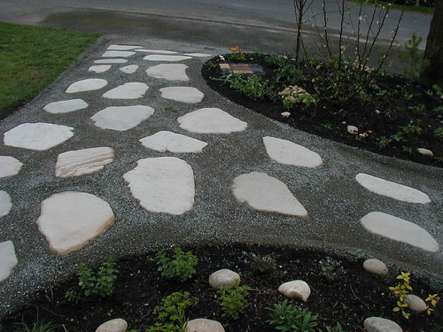
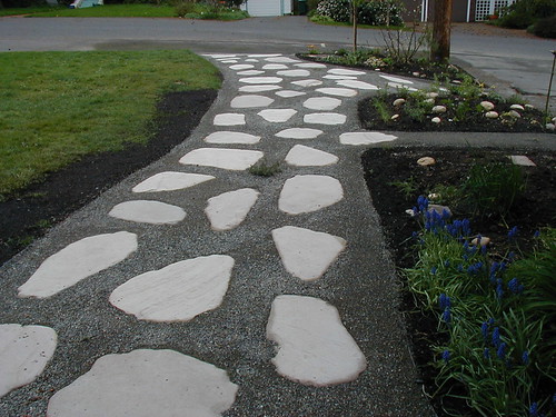
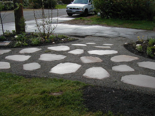
We mentioned that we used Wilkeson sandstone for the recent entry project (above)

Visiting the quarry and meeting the current owner was a beautiful and memorable experience

here's what we've learned about Wilkeson sandstone so far...

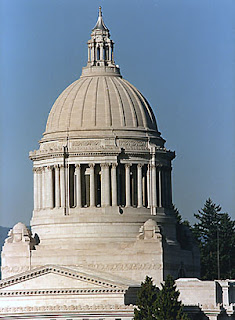
it's most famous application in Washington state is as the facing for the State Capitol building in Olympia

from HistoryLink.org:

Coal was mined in Pierce County between the late 1870s and the late 1930s, spurring the development of mining communities in the foothills of Mount Rainier. Although there were also family farms in the area, life in Pierce County's coal-producing region revolved around the mines.

Coal was discovered at what would become Wilkeson in 1875, and in 1876 the Northern Pacific Railroad built a spur line to the area. Wilkeson, named for Northern Pacific Railroad secretary Samuel Wilkeson, was the only coal-mining town in the region not owned by a coal company. When the mines closed, the town reinvented itself as the gateway to Mount Rainier National Park. The area also has significant outcroppings of sandstone, and beginning in 1883, Wilkeson sandstone was quarried commercially for use in construction. It has been used in buildings throughout the state, including in the dome of the Washington State Capitol in Olympia.


from Energy Storm:

The Wilkeson Sandstone is a light-gray (N 7--8), very well-indurated, fluvial, lenticular, well-sorted, medium- to coarse-grained, arkosic sandstone. Located near the northwest corner of Mount Rainier National Park, west-central Washington State, the Wilkeson Sandstone is an important key rock that was included in part of the former Wilkeson Sandstone(s)/Wilkeson Formation (Willis, 1898). Incorporated into the Eocene Carbonado Formation (Gard, 1968), it is often referenced in Puget Group geological studies. The Wilkeson Sandstone was derived from an eastern highland of plutonic, metamorphic and marine sedimentary rocks, and contains minor carbonized wood debris, and rare siltstone and mudstone clasts. The cross-bedded, subangular, bimodal, first-cycle sand grains are cemented by silica, with secondary nodules of specular hematite.The unit weathers grayish-orange (10YR 7/4) and black (N 1).

from the University of Puget Sound's Arches Unbound:

Wilkeson Sandstone [is] a whitish, 40-million-year-old rock deposited in deltas in what would become Puget Sound. At the time, neither the Cascades nor the Olympics had risen and the local climate was tropical with palms and tree-sized ferns. The Wilkeson, quarried near Mt. Rainier, is the most commonly used building stone on the Puget Sound campus, especially in the earlier buildings, such as Thompson Hall and Collins Library, where its light color contrasts gracefully with the red brick. (The Wilkeson characterizes so many UPS buildings that when architects designed Phibbs Hall, many years after the original quarry closed, they won an award for creating faux Wilkeson out of concrete.)


3" Wilkeson sandstone for sale at Marenakos stone yard

from
Geology of the Black Diamond-Wilkeson Area
Field Trip Questions


by Dave Knoblach
Outcrop Geological Services

The Wilkeson quarry was used for building stone of the State Capitol buildings in Olympia. The mill site is listed on the National Historic Register. In the late 1800's, geologists determined that the Wilkeson sandstone is located immediately above the top of the local productive coal seams. Above this sandstone the coal generally was a lower grade and not economic to mine (lower heat output). Every prospector in the area looked for this sandstone when seeking new coal mines because the good coal was located directly below.

The Wilkeson sandstone was deposited about 40 million years ago. Long before the Cascade Mountains formed, the region was a broad low-laying plain. Rivers drained mountains located far to the east, possibly as far away as Idaho. The Wilkeson area was a delta plain, located near the brackish waters of the Pacific Ocean. The delta plain contained a meandering river with adjacent subtropical swampland that later turned into coal.

[T]he bedding in this quarry dips to the right. This is the opposite direction of the same sandstone layer in Wilkeson. These two sections of sandstone were once connected in a horizontal layer. It was later folded into an arch-like form called an anticline. The sandstone extended above the top of the valley from here to Wilkeson, but the upper portion of the anticline was later eroded.

(unknown location)

[...] This quarry switched operators over its many years of production. Some years back a new operator started quarrying the sandstone on the left (west) side of the quarry (at the bottom of the sandstone unit). They ran into shales, and coals and could not find any good sandstone. Shortly thereafter they quit their operations here saying that they couldn't predict where the good sandstone was located [...] The owners walked away from a perfectly fine deposit because they didn't know how to read the rock. The current operator is working along strike like should have been done and has found plenty of rock.

Labels: , , ,

Saturday, 14 April 2007

recent work

here are some images from the front yard and path project we've been working on in seattle this spring


you can see more on our flickr page. all the currently uploaded photos are in a set here.


Wednesday, 11 April 2007

completion

completion!
pictures will be posted soon...
watch the flickr group first

back to cali :)

Saturday, 7 April 2007

Wedgewood path nearing completion!

We are just wrapping up our current project in seattle. New photos will be taken monday, and posted here sometime next week...

For now you need a free membership at flickr.com to see more in-progress shots at
http://www.flickr.com/groups/messagefromyard/

quince currant and pine

On Easter yes-I is hoping to garden at Kripa Mandir in Birch Bay, before returning to Cali early next week...