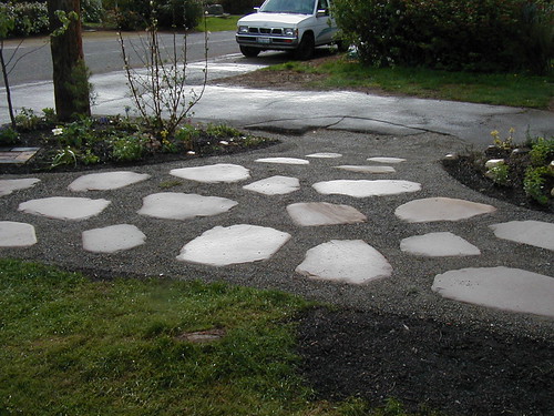
Wilkeson Sandstone

We mentioned that we used Wilkeson sandstone for the recent entry project (above)
Visiting the quarry and meeting the current owner was a beautiful and memorable experience

here's what we've learned about Wilkeson sandstone so far...
it's most famous application in Washington state is as the facing for the State Capitol building in Olympia
from HistoryLink.org:
Coal was mined in Pierce County between the late 1870s and the late 1930s, spurring the development of mining communities in the foothills of Mount Rainier. Although there were also family farms in the area, life in Pierce County's coal-producing region revolved around the mines.
Coal was discovered at what would become Wilkeson in 1875, and in 1876 the Northern Pacific Railroad built a spur line to the area. Wilkeson, named for Northern Pacific Railroad secretary Samuel Wilkeson, was the only coal-mining town in the region not owned by a coal company. When the mines closed, the town reinvented itself as the gateway to Mount Rainier National Park. The area also has significant outcroppings of sandstone, and beginning in 1883, Wilkeson sandstone was quarried commercially for use in construction. It has been used in buildings throughout the state, including in the dome of the Washington State Capitol in Olympia.
from Energy Storm:
The Wilkeson Sandstone is a light-gray (N 7--8), very well-indurated, fluvial, lenticular, well-sorted, medium- to coarse-grained, arkosic sandstone. Located near the northwest corner of Mount Rainier National Park, west-central Washington State, the Wilkeson Sandstone is an important key rock that was included in part of the former Wilkeson Sandstone(s)/Wilkeson Formation (Willis, 1898). Incorporated into the Eocene Carbonado Formation (Gard, 1968), it is often referenced in Puget Group geological studies. The Wilkeson Sandstone was derived from an eastern highland of plutonic, metamorphic and marine sedimentary rocks, and contains minor carbonized wood debris, and rare siltstone and mudstone clasts. The cross-bedded, subangular, bimodal, first-cycle sand grains are cemented by silica, with secondary nodules of specular hematite.The unit weathers grayish-orange (10YR 7/4) and black (N 1).
from the University of Puget Sound's Arches Unbound:
Wilkeson Sandstone [is] a whitish, 40-million-year-old rock deposited in deltas in what would become Puget Sound. At the time, neither the Cascades nor the Olympics had risen and the local climate was tropical with palms and tree-sized ferns. The Wilkeson, quarried near Mt. Rainier, is the most commonly used building stone on the Puget Sound campus, especially in the earlier buildings, such as Thompson Hall and Collins Library, where its light color contrasts gracefully with the red brick. (The Wilkeson characterizes so many UPS buildings that when architects designed Phibbs Hall, many years after the original quarry closed, they won an award for creating faux Wilkeson out of concrete.)

3" Wilkeson sandstone for sale at Marenakos stone yard
from
Geology of the Black Diamond-Wilkeson Area
Field Trip Questions
by Dave Knoblach
Outcrop Geological Services
The Wilkeson quarry was used for building stone of the State Capitol buildings in Olympia. The mill site is listed on the National Historic Register. In the late 1800's, geologists determined that the Wilkeson sandstone is located immediately above the top of the local productive coal seams. Above this sandstone the coal generally was a lower grade and not economic to mine (lower heat output). Every prospector in the area looked for this sandstone when seeking new coal mines because the good coal was located directly below.
The Wilkeson sandstone was deposited about 40 million years ago. Long before the Cascade Mountains formed, the region was a broad low-laying plain. Rivers drained mountains located far to the east, possibly as far away as Idaho. The Wilkeson area was a delta plain, located near the brackish waters of the Pacific Ocean. The delta plain contained a meandering river with adjacent subtropical swampland that later turned into coal.
[T]he bedding in this quarry dips to the right. This is the opposite direction of the same sandstone layer in Wilkeson. These two sections of sandstone were once connected in a horizontal layer. It was later folded into an arch-like form called an anticline. The sandstone extended above the top of the valley from here to Wilkeson, but the upper portion of the anticline was later eroded.
[...] This quarry switched operators over its many years of production. Some years back a new operator started quarrying the sandstone on the left (west) side of the quarry (at the bottom of the sandstone unit). They ran into shales, and coals and could not find any good sandstone. Shortly thereafter they quit their operations here saying that they couldn't predict where the good sandstone was located [...] The owners walked away from a perfectly fine deposit because they didn't know how to read the rock. The current operator is working along strike like should have been done and has found plenty of rock.


0 Comments:
Post a Comment
Subscribe to Post Comments [Atom]
<< Home